Water trickles under a rock the size of a Volkswagon Beetle. Their surfaces spattered with gray-green lichen, more enormous diabase boulders squat over the stream channel. The stone is smooth, worn down by the elements. Small depressions in the rock create catch basins; a startled frog leaps from one of the pools into a crevasse and disappears with a splash. Most of the stream, in fact, flows under the rocks. Perched on a boulder, I try to imagine life in a watery underworld.
The rocky streambed provides a perfect habitat for amphibians; its vernal (temporary) pools provide refuge from fish that would eat young newts and tadpoles. Spotted Salamanders, Wood Frogs, and Gray Treefrogs feel at home there. When the frog leapt into the crevasse, it probably knew exactly where it was–and where it was headed.
I, on the other hand, do not.
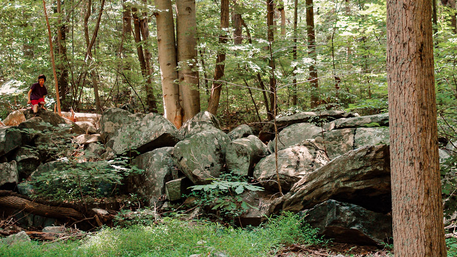
A rugged, forested landscape, Sourland Mountain can confuse novitiates. Ancient rocks, over a hundred million years old, rise up from the forest floor: rocks the size of fists, of basketballs, of small cars. After a few hours in the boulder fields, they start to look identical. So do the trees. The second-growth forest took root when quarrying activities stopped; having sprouted at the same time, most of the trees are the same size. Supposedly compasses don’t work in the rocky landscape. My own sense of direction is off-kilter. I sit on a rock and ponder the convergence of five footpaths where there should have been three. For all the warning chatter of a blue jay, I am hardly the only person to amble by. I decide to wait and get my bearings. If that fails, a birder or a leaf peeper might amble by.
More ridge than mountain, Sourland Mountain rises, at most, 500 feet skyward. But what it lacks in height it makes up for in length. The mountain-ridge runs from the Delaware River by Lambertville northeast to Hillsborough, tapping three counties on the way: Hunterdon, Mercer and Somerset. It rises through parts of Hopewell Borough and Township, Montgomery Township, East Amwell Township and West Amwell Township and traverses four major watersheds. It also provides an almost twenty-mile band of forest.
The thought provokes concern for my feet.
Happily, the hiking boots are a vast improvement over the gear I wore when first visiting the preserves. At the base of one trail a hiker, dubious, stared at my sneakers. (To add insult to injury, the shoes sport a fashionable plaid.) He looked at my feet much the same way I had stared at an old photo of Victorian ladies in high heeled, lace-up boots, smiling from atop a particularly large rock on Sourland Mountain.
“Take care,” he says.
“You too.”
“Take care,” he repeats, this time with a heavy emphasis on the verb.
The trails, tortuous, head down, wind around rocks, and snake back up the hill. I had swung back in the general direction of the parking lot, only to find myself facing the same set of boulders. Twice. Strictly speaking, I know where I am: on the south flank of the mountain and west of my car. The problem lies in connecting the dots. The sun has dropped below the ridge; it would be nice to resolve this dilemma soon. The region contains too much land to explore in one day–too much meaning a whopping 25,000 acres of contiguous forest, 7,500 acres of wetlands and 18,000 acres of active farmland.
Sympathy begins to develop for early settlers. It is easy to imagine the region’s name sprang from the ire of victims rooked in shady land deeds; up on the mountain, rock had to be harvested first. It went into walls, dams, mills, and foundations. Frost heaves and spring melts produced a fresh harvest. Some boulders–and boulder fields–were simply too imposing. The locals conceded defeat and named the most prominent: Three Brothers, Devil’s Half Acre, Devil’s Featherbed, Knitting Betty. On occasion, people proved equally hard to extract. John Hart, a signer of the Declaration of Independence, used the mountain as a hiding place from the British. The redcoats could not have been happy, hunting a fugitive in a rock-strewn ridge that rises up like a gnarled, varicose vein over the smooth skin of the land below.
Bootleggers, slaves, hippies, criminals: the mountain’s history provides ample inspiration for writers and folk musicians, even if the bootleggers are long gone and the back country shacks have disappeared.
And yet, for all those early difficulties, the mountain’s name might well have come from the sorrel color of the earth. Its minerals enriched the soil of the valleys, and water from the mountain’s streams and tributaries fed countless mills. The region, in fact, grew to become a vibrant agricultural center until budding industrialization and a failed peach crop lured farmers to the cities. Some who stayed did perhaps the most logical thing; they farmed rock. Quarries extracted diabase (also called trap rock) for use in railroad beds, roadbeds, and concrete. The crop still stands. Now it provides entertainment, even if, at the moment, entertainment resembles an outing in a corn maze.
Today much of the Sourland Mountain region, particularly to the south, is a land of quiet beauty. Rocking chair porches grace homes. Old hamlets still host country stores. Some roads, such as Montgomery’s Long Hill Road, can be as quiet as a country road in southern Vermont. Ironically, the land provokes dreams that threaten that same peace. Tremendous development pressure threatens a region than cannot easily support dense housing. Although streams and groundwater supply the Delaware & Raritan Canal, providing drinking water to over one million people, the area is infamous for its poor wells. As a result, conservationists and historians have fought–often successfully–to preserve hundreds of acres for green corridors and historical preservation.
Some locals are equally anxious to preserve the region’s cultural heritage. Every summer, the Hillsborough Gold and Country Club hosts the Annual Sourland Music Festival, a jamboree to benefit the Sourland Planning Council. The council, according to its website, strives “to protect the ecological integrity, historical resources and special character of the Sourland Mountain region.” The event is the brainchild of Tom Kilbourne and Jim Popik, both of Hopewell Township and trustees of the SPC, and Reverend Truman Madison Goines of Lambertville.
Drumming up musicians might be a challenge, given the organization’s mandate that all performers have a strong connection to the region. But Mr. Popik performs with the Ten Foot Tall Band, whose members boast of having “funk in our feet, blues in our gut, jazz in our heart”.
The artist with perhaps the greatest claim on the region is Reverend Goines, who writes and performs folk songs about the mountain and the people who lived on it. On a CD recorded with Jr. Bliggins (a native New Jerseyan originally named Robert Liana Jr.) and titled “The Legend of Jr. Bliggins & The Rev. Truman Goines, Vol I”, tracks include “Lost John”, a song about John Hart’s flight from the British. Another track, a harmonic piece titled Lambertville Station, simulates a train pulling from a station and the chugging engine of a Model T.
The region provides ample material. “New Jersey’s Sourland Mountain” by T.J. Luce, published by the Sourland Planning Commission, describes a rich culture forged by the rocky mountain. Ghosts, haunts and scoundrels weave through the stories, in particular those in a chapter titled “Shady Characters.” Mr. Luce writes of a mountain that was, for at least part of its history, known for murders and moonshine. In one account, an illegal still polluted a stream to the extent that pigs downstream became drunk.
Bootleggers, slaves, hippies, criminals: the mountain’s history provides ample inspiration for writers and folk musicians, even if the bootleggers are long gone and the back country shacks have disappeared. The mountain inspires other visitors as well: guests who do not know of the cast of characters that once roamed the woods. Now people come for the thrill of bouldering and the cardio-workout of an afternoon rock scrambling, while others choose more serene outings. Naturalists look for threatened and endangered animals, such as the barred owl, Cooper’s hawk, and the wood turtle, that call the mountain home. They look for elusive bobcats and coyotes, and the red and gray fox that hunt along the meadows. By fall, as the leaves shift to brilliant hues of yellow, orange and scarlet, birders count migrants that stop to recharge on their long journeys south.
A woodpecker drills into a tree. Suddenly the forest feels familiar. Another woodpecker had worked a branch by an outcropping where a yearling doe had fled my approach. Landmarks – vernal pools, fallen trees, and ruined walls – materialize out of a terrain that had seemed oppressively uniform. The trail that dips and turns east leads to a series of boardwalks, which lead to the car. From the parking lot it is a short drive to the towns in Amwell Valley and local cafes, where it is sometimes possible to hear locals craft their own history of the Sourlands.
Paths of green, fields of gold!
Part of the Morristown National Historic Park, the formal walled garden, 200-foot wisteria-covered pergola, mountain laurel allee and North American perennials garden was designed by local landscape architect Clarence Fowler.
The Millstone Scenic Byway includes eight historic districts along the D&R Canal, an oasis of preserved land, outdoor recreation areas in southern Somerset County
Artisanal cheeses, wood fired breads, 100% grass-fed beef, whey fed pork, and suckled veal, 100% grass-fed ice cream, pasta made with Emmer wheat and our own free-range eggs, and pesto made with our own basil! Bread and cheesemaking workshops are held on the working farm as well as weekend tours and occasional concerts.
The Jacobus Vanderveer house is the only surviving building associated with the Pluckemin encampment.