A former railbed just north of the Delaware Water Gap provides another short but satisfying taste of days past in a beautiful setting. Designated as the "Karamac Trail" by the NY-NJ Trail Conference map, most of this trail is the former railbed of the New York, Susquehanna & Western Railroad Company. A shorter second portion of the Karamac trail passes through the site of a former resort. For most of the way the trail also parallels the Old Mine Road, the oldest public road of any appreciable length in the nation and which possesses quite a few interesting features and mysteries of its own. The flat, one-mile railbed portion of Karamac Trail is described here.
The old railbed is a particularly good trail to hike as sunset approaches because for much of the trail you will be able to see the setting sun through the trees. Also, because it is less than a mile long, you will be able to get back to your car before it becomes too dark. This short trail is also perfect for those who are not inclined to hike longer, more difficult trails. A few sections can be somewhat damp or muddy at times so hiking boots are recommended.
To get there take I-80 West towards the Delaware Water Gap, getting off where the sign indicates "Flatbrookville, Millbrook Village", the last exit before the bridge to Pennsylvania. Turn right at the stop sign onto Old Mine Road and park at the small area along the riverbank just before the traffic light. This is the trailhead(1) for the railbed portion of the Karamac Trail.
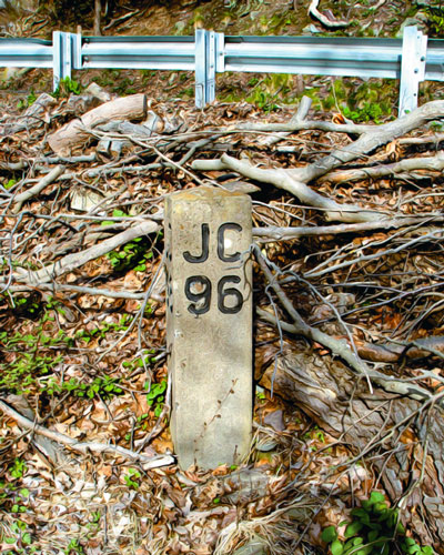
Look back from the parking area under the I-80 bridge. Although all traces of the former railroad have disappeared, you will see where it once passed. Just around that curve was the long-gone town of Dunnfield and its railroad station. From there the railroad headed to points eastward. As you begin your hike it's only a few steps before you see an old railroad mile marker that proclaims "JC 96", indicating 96 miles to Jersey City .
The entire length of the trail follows closely alongside the Delaware River dozens of feet below. A look toward the rock cliffs on your right show evidence of a construction technique called "cut-&-fill". Railroad builders blasted away sections of the cliff, partially forming the railbed on which the track would be laid. A look over the edge almost anywhere along the first half of the trail reveals the huge amount of blasted rock that was dumped there to build up the flat railbed on which you are walking.
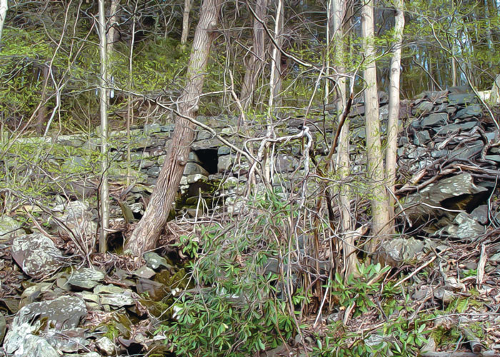
As you walk down the trail it's hard not to notice the beauty of the river flowing below on your left. But don't let it distract you from the Old Mine Road passing high above to your right, supported by its own cut-&-fill construction. You'll soon see the rough but well-crafted stonework of a very old roadway drainage culvert. The fact that it still stands is testimony to the skill of its builders. Shortly beyond, the rail trail passes alongside a rough-dressed stone wall(2), another good example of some former stonemason's skill. The wall appears to have been constructed to help support Old Mine Rd high above. Just a short distance away you will see modern concrete cribbing placed there a decade or so ago to support the road's collapsing support base at a place where it seems to be suspended from the side of the overhanging cliff above.
A few minutes beyond the modern cribbing, the cliffs on your right suddenly drop back from the road above. This is what was once known locally as "Groundhog Hollow" where a formerly active bear den is located a few hundred yards up the hill, possibly home to a mother bear and her cub even this past winter.
The trail then passes over three wide areas in the railbed, one after the other. Look at each of these wide areas and the ruins that are present, trying to seek clues as to what was once located there. Peek over the edges of the steep drop-offs and look at the supporting stonework. Imagine what effort went into the construction of these ancient retaining walls.

The first of these wide areas is located just after the rail trail passes through a rock "cut". Look over the edge of the river bank at the toppled cast concrete wall sections below. Notice the decorative concrete work and wonder who went to the trouble of forming these details in what appears to only have been a utility wall. What was supported by the concrete pylon on the bedrock at the river's edge below?
Looking out into the Delaware River, you will notice a large island called Schellenbergers Island on modern topographic maps. It was this island that once held Island Park, a simple amusement park from another era with a bathing beach, merry-go-round, and picnic area. An old Island Park postcard shows bathers and onlookers enjoying the pleasures of the river, including boating and a water slide. Considering the railroad once passed here, is it possible they might have dropped passengers off here, using one of these wide areas as an access point to the island?
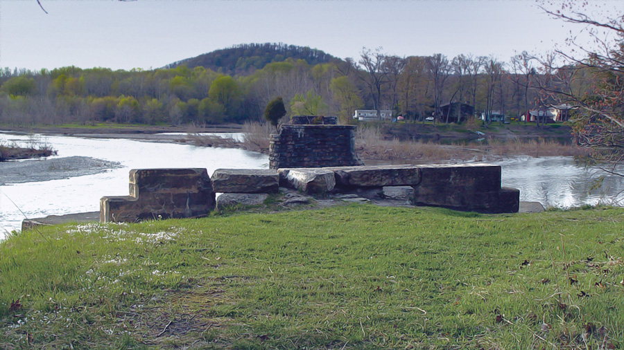
A short distance down the trail, after passing a masterfully constructed dressed stone wall(4), you will get to the second wide area, about halfway to the end of the railbed trail. Who placed the Belgian block curb here? Hanging over the steep drop to the river below is an old foundation(5) that is still partially intact in the side of the dropoffdrop-off. Imagine the structure that it once supported, jealously admiring the view of the river that it once afforded.
At the third wide area, notice all the debris on the ground. Here lies the remains of what is probably a railcar frame(6), and not far away lies a heap of sheet metal that looks suspiciously as if it were part of the railcar's body. Notice the remains of guard posts or railing supports right at the edge of the sharp drop to the river. Was this once just a private summer home or was it some sort of concession or station?
For the rest of the trail, you will pass through what might appear to be seemingly featureless terrain, at least if you are looking for signs of human construction. It takes sharp eyes to find the two old foundations up on the hillside near Old Mine Road. Or how about the masterful rockwork of the culverts over which the rail trail passes and through which flow the occasional small streams you pass over? Among the human debris, you might even pass a fox den, hidden in plain sight.
Finally, you come to the trail's end, jutting out high above the Delaware River. There are no barriers or warning signs to let you know that the trail ends abruptly on the first support pier (7) of the former NYS&W bridge over the river. From here, the view is breathtaking. Imagine the amount of engineering and labor it took to build the support piers. Or the effort to place the structure that once connected the pier you are standing on to the next one, way out there in the river. Awesome, indeed!!
This is the area of Camp Karamac, a popular resort during the middle 1900s that catered mainly to young adults. Looking around at what first appears to be untouched natural surroundings, it is hard to believe that a camp of Karamac's stature was ever here. (It was the subject of a feature story in a 1951 Saturday Evening Post.) Karamac's attractions included boating from a choice of launch areas, tennis, beauty contests, concerts, dance contests, square dancing, just about any sport imaginable at an outdoor camp and a barrage of orchestrated entertainment. There were tennis courts, and among the cabins was a large recreation hall known as the Wigwam which had a dance floor, stage, and its own band.
Once you are at the bridge piers, you are at the end of the rail trail. If you have taken this hike near sunset, you will have just enough time to hike back to your car before it becomes uncomfortably dark. If some daylight hours remain, maybe you can find the rest of the trail that leads from the area of the bridge pier up to the Karamac parking area(8). The change in terrain for that portion of the trail is dramatic should you choose to take it.
If you are interested in developing your skills with your GPS, you
can try to locate some of the features mentioned in this trail description
by entering the latitudes and longitudes as given below into your GPS.
A route for this hike can be established by entering them in the order
given.
(1) Trailhead by 3-minute light N40º 58.616', W75º 08.044'
(2) Rough-dressed stone wall N40º 58.751', W75º 07.972'
(3) Decorative concrete ruin on bank N40º 58.898', W75º 07.888'
(4) Dressed stone wall N40º 58.917', W75º 07.887'
(5) Foundation ruins in the river bank N40º 58.949', W75º 07.877'
(6) Railcar frame N40º 59.089', W75º 07.855'
(7) Bridge pier of former NYS&W bridge N40º 59.339', W75º 07.859'
(8) Karamac parking area N40º 59.332', W75º 07.679'
Choose and Cut from 10,000 trees! Blue Spruce, Norway Spruce, White Pine, Scotch Pine Fraser Fir, Canaan fir, Douglas Fir. Family run on preserved farmland. Open Nov 29 - Dec 23, Tues-Sunday, 9-4. Easy Access from Routes 78 or 80.
A fine art gallery like no other! Unique, handmade gifts and cards as well as yoga, meditation, and continued learning lectures. Come in Saturdays for all-day open mic and Sundays to try unique nootropic chocolate or mushroom coffee. Browse the $5 books in the Believe Book Nook while you nibble and sip.
Local roots!
The 8,461 acre park includes the 2500-acre Deer Lake Park, Waterloo Village, mountain bike and horseback trails.
Millbrook Village, part of the Delaware Water Gap National Recreation Area, is a re-created community of the 1800s where aspects of pioneer life are exhibited and occasionally demonstrated by skilled and dedicated docents throughout the village