Phonetically "pa-sippo-nong", from the native Lenne Lenape name for "rushing water place", Parsippany is a sprawling highway crossroads on the eastern side of Morris County; where the waters still flow, but commuters now do most of the rushing. The township, largest in Morris and located within in the Passaic River watershed, is bordered by the Rockaway River from which the town's name came to be, and has a very favorable ratio of more than 1 acre of parkland for every 100 residents. Passing through at 65 miles per hour (or not, as many a commuter will tell you) doesn't give much hint about what open space might be on the other side of those familiar acoustic barriers, but the township's Colonial past and agricultural, and industrial heritages have left some interesting places to see.
This 190-acre municipal park at the far southwestern corner of the town is also the location of the highest point above sea level in Morris County, Watnong Mountain. The vistas from the mountain were important during the Revolutionary War for signaling, and the detection of troop movements. The posting was then known as Beacon Hill, and for troops of the Continental Army, had a commanding view of much of north Jersey; looking north, east, and south, from its slopes. Though charcoal remnants of the beacons left in the soil (think the movie Lord of the Rings) have long since been displaced by human activity, stone steps up the southwest side of the hill that were built by the Continental Army are still there for climbing and exploration.
The Continental Army had plenty of stones to choose from, as the mountain is a classic example of terminal moraine, the geological formation of earth and rock pushed up at the limit of a glacier's advance. The steps are clearly visible from the southern loop of the 1.1 mile Beacon Hill Trail, as one enters the mountain side of the park from the parking and playground area on Mountain Way, and taking the path to the right. Clearly blazed, other glacial rock outcroppings dot the trail as it circles south, east, and then north, passing west of the base of the water tower at the top of the mountain. Continuing north, a side trail leads to the tree line at the north side of the park, where an overlook provides a broad view of Sussex, Morris, Passaic, and Essex counties. For the spry, a shorter hike jogs to the overlook via the north loop of the trail on the left, but expect a very slight bit of difficulty as you make your way up. The reward for taking this more difficult path is the view of some of the most dramatic outcroppings of glacial boulders, and rockfalls, in the park.
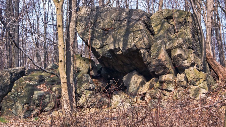
Known to generations of local school kids as the Rock House, the Parsippany Rock Shelter is a collection of titanic glacial boulders that tumbled to form a rudimentary shelter. Evidence of human habitation extends as far 1250 BC, and as recently as the late 1500s by the Lenne Lenape indians. Although there's no conclusive evidence for the location as a calendar site, it may have had astronomical significance in prehistory. The landmark contains a rare New Jersey example of Indian petroglyphs, thought to have been etched into the rock between 500 BC and 500 AD. Care has been taken to isolate and protect the glyphs, which depict animals and human figures, for future study and scholarship. The landmark property and shelter are accessible from Dale Road, off Park Road, between Littleton Road (US Hwy 202) and Tabor Road (State Hwy 53).
There are some fine examples of colonial architecture in the township, but the most prominent are the Benjamin Howell House on South Beverwcyk Road, and the Livingston Benedict House on Old Parsippany Road.
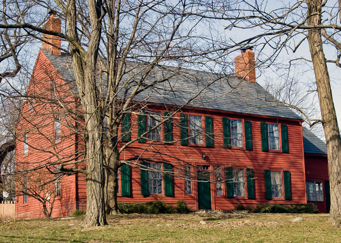
With the slight bend in the course of Interstate Route 80 at the south end of the property, an accommodation to the preservation of the structure from road vibration, one might say that the most care given to a Parsippany landmark has been that given to the Livingston Benedict House. Built in 1752, the house was rented by New Jersey's first elected governor (1776 to 1790), William Livingston, as haven from British troops garrisoned in his home town of Elizabeth, and near the military capital of the Revolution, Morristown. The site was the location of an attempt by British sympathizers to kidnap the Governor, who eluded capture by sneaking past the sleeping Tories. Later construction at the home dates from 1830. Livingston Benedict house is located at 25 Old Parsippany Road, off Lanidex Plaza West.
The Benjamin Howell House was built in 1763, but the enlarged home we see today dates from construction that completed in 1793. From an original parcel of land totaling 160 acres in 1761, Howell sited his home along a one of the routes travelled frequently enough by forces of the Continental Army between Morristown and West Point, to be called "Washington's Trail". Historical records show the home was the site of military conferences associated with the famous winter encampment of the Continental Army and General Washington in and around Morristown in 1779-1780. The 1793 Federal-style expansion established the spare, symmetrical design that stands as an exemplar of New Jersey homes of the period.
Other interesting homes in Parsippany include the Bowlsby-Degelleke House, located on Baldwin Road and now the Township of Parsippany-Troy Hills museum, and the Stephen Condit House on North Beverwyck Road.
Parsippany's town museum was constructed in 1798, and since 1978 has been in the National Register of Historic Places. Known as the Bowlsby-Degelleke House, the house and property are under renovation for eventual use by the Township's Historical Committee and the Parsippany Historical Preservation Society. The House is a 1 1/2 story clapboard construction home, with chimneys at each gable end. Renovation is scheduled to complete by late April of this year, and the museum re-opens with a ribbon-cutting ceremony on Sunday, May 17th. The Bowlsby-Degelleke House is located at 320 Baldwin Road, off US Hwy 46.
The Stephen Condit House on North Beverwyck Road is a late Victorian design of clapboard construction dating from 1870. Once the main house of the Condit family's extensive property to the east of Beverwyck Road, the home was renovated in the 1990s, after the passing of the last of the Condit family, Stephen Hobart Condit, in 1983. Constructed with elements of both Carpenter Gothic and Italianate Victorian styles, it was said to be the first home in Parsippany with indoor plumbing. Today the home serves as a community center for the condominiums that were developed on the Condit property. The house can be seen prominently at the corner of North Beverwyck Road and US Hwy 46.
The Stickley Museum at Craftsman Farms is a treasure of Arts & Crafts design history, dating from 1911. On 26 acres of land, and operated by The Craftsman Foundation, the Museum's home is the central lodge to a series of smaller structures built by Gustav Stickley, founder of the Arts & Crafts movement in America. Stickely's vision of a sturdier, simpler aesthetic that resisted the finery of the Victorian style, with a renewed emphasis on craftsmanship, came to fruition at the Farms, where students apprenticed in the design and woodworking. The Stickley Museum at Craftsman Farms is located at 2352 State Route 10 West. more...
Named one of the "Best Places" by Golf Digest for 2008-2009, the 360 acre semi-private and municipal courses of the Knoll Golf club stretch along the Rockaway River, on the northeast side of town. Knoll Golf Club West is a semi-private, par 70 course with 6752 playing yards from the blue tees, and from the white tees, 6479 yards. Established in 1929, the course was designed by Charles H. Banks. The course features a Tee House with refreshments between the ninth and eighteenth holes, and the use of motorized carts is mandatory.
The course at the Knoll East Golf Club, established in 1961, was designed by Hal Purdy. Another par 70 course with 5884 playing yards from the white tees, the course is a public facility. Walking is permitted at all times, and motorized carts are available. Tee times are available first come first served. Access to Knoll Park is from the entrance at 1200 Knoll Road.
Thanks to Michele Sylvin, Coordinator, of the office of Mayor Henry Luther, Pat DeFalco, Superintendent of the Knoll Country Club, Mary Purrzycki of the Parsippany-Troy Hills Twp Historical Committe, and Vonda Givens, Educational Director, of Craftsman Farms, for their help with this article.
Paths of green, fields of gold!
The Millstone Scenic Byway includes eight historic districts along the D&R Canal, an oasis of preserved land, outdoor recreation areas in southern Somerset County
Part of the Morristown National Historic Park, the formal walled garden, 200-foot wisteria-covered pergola, mountain laurel allee and North American perennials garden was designed by local landscape architect Clarence Fowler.
The Jacobus Vanderveer house is the only surviving building associated with the Pluckemin encampment.
Dedicated to preserving the heritage and history of the railroads of New Jersey through the restoration, preservation, interpretation and operation of historic railroad equipment and artifacts, the museum is open Sundays, April thru October.