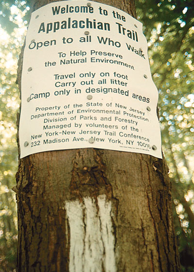
Bean and Lady Jane sat on the sidewalk of a deli in Warwick, NY, near the beginning of the Appalachian Trail's entrance to New Jersey, chowing down sandwiches and sodas; food they hiked seven miles off the Trail to get. Their rat terrier munched with them, part of this happy AT through-hiker group. Two tall, stuffed backpacks leaned against the wall, bulging with gear to last them from West Virginia to Maine. It took a month to make it to Jersey--and they saw three bears on the trail--all here. Spirit sparkled in their eyes. Their smiles and words encapsulated me. Now, my own soon-to-be adventure on the Jersey AT demanded to be done. I told them my hiker buddy and I, both women in our 50s, aren't hikers, never camped out nor tossed food over tree branches to keep it away from hungry, wild animals. Lady Jane encouraged me "You don't have to get in shape before you go on the trail. The trail will get you in shape."
Friday noon-- We toss our gear into Kathleen's car and hop in with Petey, my 125 pound German shepherd cross. (My vet warned me a week ago, "I hate to tell you this, but that dog's no athlete."). The plan is to hike from the Gap to High Point in four days and three nights, arriving there on Monday. At the Dunnfield Creek parking lot off Route 80 near the Delaware Water Gap we get ourselves together, so to speak. Our goal today is to make it to Mohican Outdoor Center, nine miles northeast and uphill, high above Blairstown.
Kathleen puts bug spray on her face before her sun block, and now her hands are coated with DEET. Petey has his pack on and is ready to go, after drinking a pint of water. I am having a minor heart attack under my borrowed pack that is teetering on my butt like the World Trade Center.
We climb along Dunnfield Creek. The trail's rocky and steep as we huff onward. It splits from the AT for a while until the forks meet again at Sunfish Pond. We're taking this trail because it is more scenic and less rugged, we're told. It's gorgeous--every little waterfall and pool with still water. Stopping briefly at a waterfall, K zips off the legs of her high tech pants, and Petey has a water break. The waterfall has stepped rock, carved like stairs to a water-walled cathedral--reminds me of being a wood nymph. Although this is a backpack of 1970s vintage, and kind of wobbly, it's beginning to feel comfortable.
We discover that if we walk slowly, we get farther. To conserve energy, K will tell me to slow down and I'll tell her to not swing her pack through the air to get it on her back.
About three miles from the river we begin to get away from highway noise. Just dropped my tape recorder in the creek. After a peanut butter and jelly break and a dip in the creek for Petey, we head up the rocky trail to Sunfish Pond. There's a huge tree lying across the path, and we fight our way around it through blueberry and brambles because Petey can't climb over it with his pack--probably neither can I.
No more bird song, no more water--the creek has disappeared. We climb solid rock to the end of the world. Suddenly there's a rattlesnake--four-inch diameter--coiled on the trail, shaking his rattle. Petey flops down to rest as we watch the rattler slide into the blueberry. K zips her pants legs on, and we toss small rocks in the bush as we pass. The blueberries up here are very good.
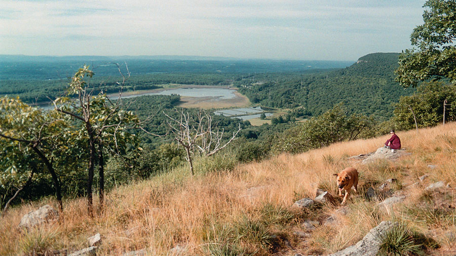
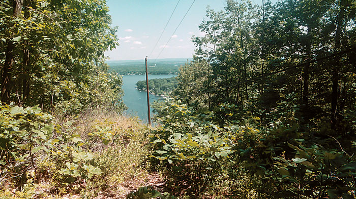
We trudge forever to Sunfish Pond, where someone tells us it's four miles to Mohican; others say it's two hours. We're told the average rate of hiking is two miles per hour and K announces she does less than one. It's about 7pm: the shadows are long. We pick our way through the boulder field around the pond, then up to the ridge by nightfall and hike with flashlights, in high places with wondrous views that we can't see.
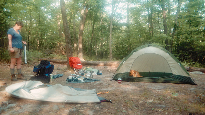
The trail becomes slabs and boulders tossed upon each other and we must climb through a narrow opening in the blackness. Petey can't make it through with his pack, so I take it off. We can't go on. Some campers help us find a good spot to pitch our tents. We pull out our tents in wonder and read the directions by flashlight. K is very thorough and does hers perfectly; I put the poles in mine without staking--too tired, besides, Petey and I will hold it down as we sleep. K's flashlight drops and the bulb breaks, thankfully after she's finished. We stuff our food into the tent sacks and trek off into the woods to find a "bear tree"--a tree to hang the food in.
Saturday - Petey loves the tent and refuses to come out. He lets it fall down around him as I remove the poles. We make tea and coffee on a big rock with K's tiny stove, over-looking the green valley of Warren County and the southernmost ridges--the best view I've ever had for breakfast. Petey eats K's steak sandwich from yesterday. Today he'll carry empty water bottles, two packets of food, ropes, bungees, and garbage. I'll carry his food and water.
We wind our way down to the Mohican road where K spots a bear. We glimpse its profile as it climbs the hill. The Mohican Outdoor Center marquis says "Enjoy watching black bears and other wildlife from a distance. Respect them and their right to live in wild New Hampshire. Food should be 10 feet off the ground and 5 feet out on a limb." We threw ours over a dead tree crotch.
Mohican has a stove, showers, good water, campsites where we set up our tents like pros, and a lodge to relax. We decide to stay till tomorrow, and with relish K cooks as I crash on a bench outside, talking with through-hikers. I trade the lodgekeeper a few days dog food for some chicken and sausage to feed Petey, who will only eat people food now. In the night I hear an eerie cry not far from the tent followed by an odd, mechanical sound. I try to ignore the unfamiliar sounds of the forest.
Sunday, noon -- We eat a great breakfast of oatmeal, rice, potatoes, coffee and tea. We gratefully fill our water bottles. The climb to the ridge is insanely steep with tall stone steps, but we've learned to take it easy. My pack feels lighter today although I carry six liters of water for Petey and me, and some of his food.
I stand on a 30 foot slab of uplifted rock that is the trail on this narrow ridge top. It soon changes and looks like a path through a wild garden with moss and grass between the rocks. Out in the open, on the ridge--on the edge--Warren County's houses stretch before us with big landscape and sky. The sound of the wind is strong and we're walking above the vultures. If it weren't for the scrub oak I might fall off. The trail stretches through a field of bright green goldenrod with bursting flowers. We see the southernmost ridges of the Skylands and are totally exposed on the side of the cliff of New Jersey. Yeah!
Confident now, Petey walks a dozen feet ahead, then flops down to rest every chance he gets. The AT winds through a sloping grassland under the trees. This part seems hardly used: we've only seen one through-hiker since leaving Mohican. We're above Route 602 and the trail skirts a bizarre looking lake with beaver-cut trees. We almost skip up a hill with a power line right-of-way with ease. I am stunned! How did I get so strong?
The trail along the southern slope of the ridge almost doesn't look like a trail and we look hard to find this bit of grass and white blazes painted on rock. Light brown moths dance around Kathleen. What do they like? Her Lubriderm or DEET? I find that I have good knees and good stamina, that I can climb a big hill with a heavy pack on my back, and I don't know why. We come out of a tight stand of green and white striped mountain maple onto a grassy old carriage road with the weeds of civilization--thistle, dandelion, clover, burdock. Our goal today is to reach Culver Lake but it's dusk and we're almost out of water. We find a grassy spot away from the trail to pitch the tents, still in lots of light to find a bear tree on the other side of the ridge. In the night, the strange, high-pitched sound of wild creatures and light footsteps are a breath away. K hears a low grunt. Petey doesn't budge. I pass out.
Monday - I scatter Petey's food since he refuses to eat it. K has a blister on her blister. She dowsed it with antiseptic and wrapped her whole foot. We have no map of the surrounding area and don't know where we are, but today's the last stretch to Culver Lake.
Near Mount Bethel Road we find a water pump--the kind Grandpa used to make. K reads the hand-written directions that someone's placed in a zip-lock baggie. It says the water's funky and rusty but good, and that the handle needs to be pumped 15 to 20 times before water flows. K pumps till the water rolls as I take photos. She yells "Get the bottles" and fades. I try to pump, but all my strength is elsewhere--nothing happens. She says "Let me do that!" and pumps with all her bod. We fill the bottles. She says she has truly pumped iron. We drink our fill of this brown water, for who knows where the next will be.
A rock wall rises before us. I take off my and Petey's packs and toss them up to K who climbs up first. I scramble up, praying Petey will make it. He does! A while later on the ridge top, we set up the stove on a flat outcrop for earned coffee and tea. I hold the dry grasses down near the rock so they don't catch fire.
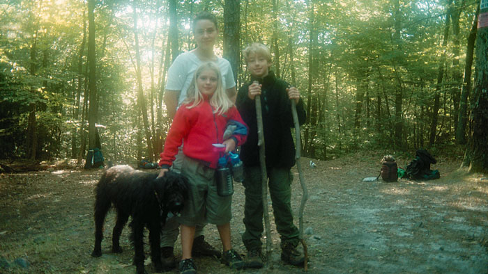
It's getting near dusk, we're almost out of water and everyone we pass says it's four more miles to Culver Lake, no matter how long or how far we hike, it's the magic four. Along comes Bob, a through-hiker we'd met earlier, and he tells us there's a shelter and a spring just two-tenths of a mile away. Voila! A woman with two kids and a dog are camping here, so we set up our tents. K wants to find the privy on the sign, find water and try out our unused water purifier, brush her teeth and maybe eat. I crash and tell her she's on her own.
Tuesday morning -- K bounds gaily down the path as I roll out of my tent. She says "The privy gives new meaning to the word 'luxury'" I check it out and agree that I am sitting in the lap of luxury. It's also a treat not having to dig toilet paper through the roots of rock-filled earth. The AT alters your sense of what's important.
K, Petey, I and the camping family get water at the stream. K breaks out our borrowed First Need water purifier with blue dye and reads the instructions. It works fabulously--fast and delicious--best water I ever drank.
The last stretch to Culver Lake is an uphill rock wash--a steady climb through hemlock and mountain laurel above the deciduous. I learned last night that I don't know when I'm tired because my body keeps going, but I'm mentally exhausted--perhaps more dangerous. I fell asleep before it even got dark and woke up way after sunrise. There's no "clipping along" the rocky AT day after day with heavy packs and looking for water. In places the trail is not well marked, but it's a natural path that makes sense. We follow the rocks when in doubt. Sometimes there are just tiny crevices where the grass is slightly flatter than the surrounding grass that's a natural place to step. That's the trail. Petey doesn't lead anymore; he's content to follow me now.
The hemlocks smell wonderful and so do the sunburned grasses, blueberry leaves, oaks and sweetfern. There's young white pine here. Thoreau's smell of pine. It's a comfortable walk on pine needles and leaf litter--soft with occasional rocks, level. We're on the top of the mountain--hope it goes all the way to Culver Lake.
I forget to look for blazes, unlike the first few days, but every now and then I look up to see one. The trail is really a natural. Sometimes in the bottom lands, with heavy tree cover, it seems like dusk and I think "better hurry!" That's how it was yesterday. It works on me mentally when I'm tired or when I don't know what time it is, which is always. Found a dime on the trail, bent over to pick it up and the pack almost knocked me down.
Longest three and a half miles ever spent. Here comes an uphill that is so grassy and pretty with sporadic rocks, it's beautiful. Couple people tell us it's 25 miles from The Gap to Culver Lake, and another 20 to High Point. What is this mileage stuff anyway? As the crow flies? Or did someone measure the turns, the uphills and the downhills? We stop on the ridgetop on a slab of rock under dappled shade for lunch and meet Chief, through-hiker. The through-hikers look great--clean, happy, ready. Chief says Jersey's great; PA's the worst and Georgia's ugly. He's heading to the bakery on 206. It's that culture thing of places to eat along the AT.
Petey's a gentleman. He does his stuff off the trail and looks at me for approval. He ate nothing today; the last of the provolone went yesterday. Wouldn't touch the salami. Threw it away.
We emerge from the woods onto the rock ledge, and there is Culver Lake. We descend with the sweet scent of sun baked grasses. "Hiking this trail, totally but totally, if you do it seriously as in exhaust your self for a couple of days at least, takes you totally, so totally away from your every day life, you can't believe it's right down there on 206. In addition to that, it encapsulates you in its own culture," says K. The people on the trail are happy says I. "It's the way people are supposed to be," says K.
Coming down into Culver Lake, the breeze is marvelous. It's towards the end of our journey and the concerns of the trail, as K says, putting one foot in front of the other, wondering where the next water supply is, how soon will it get dark, a place to camp for the night. One last meadow up on top with oak and hickory and the brown grasses and the blue breeze--the yellow blue breeze.
K spots a banana peel and a bottle cap. "We're getting to day hiker land," she says. Descending, the sound of the cars increasing, the slope of the rocks sharpening, questions of civilization start popping in my mind. The sounds pull me in. Pretty steep descent. Signs of heavy use on the trail--trampling, erosion. Good-bye sweet scent. Good-bye solitude and quietness. I'm in both worlds now, still with the trail's sweetness and beauty and the roar of tires on highways, glimpse of the lake, of people's summer homes, the rumble of freight trucks. The trail is a measure of endurance, not one of strength.
The path slices across the hill where I battle gravity. We parallel the road, down through cascades of ferns. I say I'll come back to ID these ferns, but will I? All the trappings of civilized life get in the way. I'll leave a piece of my soul here. I think how I first screamed with a 40 pound pack on my back, but after initiation day, it felt like part of my body. Crash course on getting in shape.
We've landed.
It calls me, every time I drive Route 94 and I can see the ridge, or when I drive any of Sussex or Warren County's back roads. My head rivets northward. And I promise soon....I'll be there.
“The Fluorescent Mineral Capitol of the World" Fluorescent, local & worldwide minerals, fossils, artifacts, two-level mine replica.
Peters Valley shares the experience of the American Craft Movement through interactive workshop learning through a series of workshops. A shop and gallery showcases the contemporary craft of residents and other talented artists at the Crafts Center...ceramics, glass, jewelry, wood and more in a beautiful natural setting. Open year round. Closed Thursday.
Millbrook Village, part of the Delaware Water Gap National Recreation Area, is a re-created community of the 1800s where aspects of pioneer life are exhibited and occasionally demonstrated by skilled and dedicated docents throughout the village
Choose and Cut from 10,000 trees! Blue Spruce, Norway Spruce, White Pine, Scotch Pine Fraser Fir, Canaan fir, Douglas Fir. Family run on preserved farmland. Open Nov 29 - Dec 23, Tues-Sunday, 9-4. Easy Access from Routes 78 or 80.